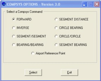
COMPSYS 21 is a free download designed to perform geodetic calculations. This user-friendly graphics interface developed for the AeroNav Services Office includes nine standard geodetic calculations.
The calculations include Forward, Inverse, Segment/Segment, Bearing/Bearing, Segment Distance, Circle Bearing, Circle/Circle, Segment Bearing, and Airport Reference Point. All geodetic computations within COMPSYS 21 are based upon the National Geodetic Survey's (NGS) forward and inverse routines.
The National Oceanic and Atmospheric Administration's (NOAA) National Geodetic Survey manages a national reference system and provides federal standards for geodetic survey.
COMPSYS 21 users can easily determine fix locations, bearing and distances. For instance, the segment/segment calculation will return the intersection of two line segments.
If the segments do not intersect, COMPSYS 21 will extend the lines to find an intersection. The results of any computation can be sent to a user-defined printer, saved/appended to a file or used for any additional calculations.
Users of COMPSYS 21 include many FAA offices including ATA, AVN, all Air Route Traffic Control Centers (ARTCCs), TRACONS, some airport control towers, NGA, and avionic companies.


Comments